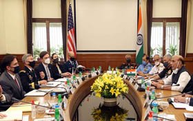
Dr Mark T. Esper, who is the Hon’ble Secretary of Defense of the USA, is travelling to India for just the 2 + 2 Ministerial Conference. On 26th October 2020, Shri Rajnath Singh, who is the Hon’ble Raksha Mantri, has had a meeting scheduled with him in the South Block in New Delhi. The two ministers addressed bilateral security cooperation, including military cooperation, stable contact and knowledge sharing networks, security exchange and industrial concerns, as well as ways to improve bilateral cooperation.
Both Ministers shared their pleasure at the close participation of the respective armed forces. They addressed possible new fields of collaboration, both at the Service-to-Service level and at the common level. They called for the continuity of existing security dialogue structures during the pandemic, at all levels, especially the Military Cooperation Group (MCG). They also addressed the conditions to extend the deployment of liaison officers.
The two ministers were satisfied that the BECA agreement would be signed during the visit. US Secretary of Defense welcomed the involvement of Australia in the MALABAR 2020 exercise.
Hon’ble Raksha Mantri expanded on the measures under ATMANIRBHAR BHARAT to promote investment in the defence industry in India and invited US companies to make use of the liberalised policies and the favourable defence industry environment in India.
India and the United States are close to signing the Basic Trade and Collaboration Agreement for Geo-Spatial Collaboration (BECA) during the 2 + 2 ministerial dialogue between India and the United States on 27 October. Long in the process, the agreement would allow India access to highly precise geo-spatial data that will have many military applications.
It is the end of the three fundamental agreements that the US signs with close allies, allowing the interoperability of powers and the sharing of confidential and secret information. While the other two apply to exchanging military logistics and facilitating safe communications, BECA aims to exchange geospatial knowledge, including nautical and aeronautical maps. Comprehensive results, complemented by highly precise US satellites, navigation aids and the targeting of military facilities.
Courtesy: PIB[/vc_column_text][/vc_column][/vc_row]

